WANT TO LEARN MORE? GOOGLE IT. :)

Showing posts with label typhoon alert. Show all posts

Sunday, December 28, 2014

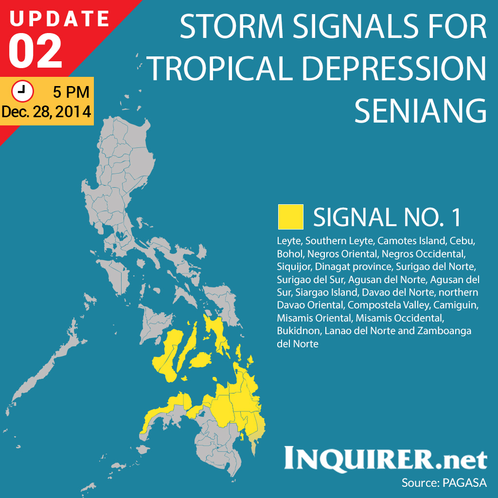
BAGYO UPDATE: Tropical depression Seniang intensifies, signal no. 1 up in 23 areas

As of 5PM today, tropical depression Seniang has intensified, local news reports, and follows a west northwest path at 13 kph and packs maximum wind speeds of 55 kph near the center. It has brought 23 areas under signal number 1.

The provinces affected by Seniang (signal number 1) are as follows:
  • Leyte 
  • Southern Leyte 
  • Camotes Island
  • Cebu 
  • Bohol
  • Negros Oriental
  • Negros Occidental
  • Siquijor
  • Dinagat Province
  • Surigao del Norte
  • Surigao del Sur
  • Siargao Island
  • Agusan del Norte
  • Agusan del Sur
  • Compostela Valley
  • northern part of Davao Oriental
  • Davao del Norte
  • Misamis Orienta
  • Bukidnon
  • Lanao del Norte
  • Misamis Occidental
  • Zamboanga del Norte
  • Camiguin
Image Link: Inquirer

Saturday, December 6, 2014

#RubyPH: Bagyong Hagupit Updates, Emergency Numbers

I found a list compiled by Inquirer.Net which enlists all the possible emergency contact details or information to take note in preparation for typhoon Ruby or Hagupit.

It's important that as early as now, everyone within or which will be within Hagupit's range be able to copy the necessary information in case power interruption and cell communication line disconnection take place. Keep safe everyone!

Social Media
Twitter:
@mmda
@philredcross
@NDRRMC_OpCen
@PNPHotline
@dswdserves

Hashtags
For aid and relief efforts — #ReliefPH
For those in need of rescue — #RescuePH
For resolved #RescuePH tweets — #SafeNow
To report floods — #FloodPH
To report missing people — #TracingPH
To report no classes — #WalangPasok

Government agencies landlines
NDRRMC Trunkline 911-5061 to 65,
NDRRMC Operation Center 911-1406 / 912-2665 / 912-5668 / 911-1873
PNP hotline: 117 / 722-0650
PNP Text hotline: 0917-847-5757
Fire Department Direct Line: 426-0219 / 426-3812 /426-0246
DOTC Central Hotline: 7890
MMDA hotline: 136
DPWH hotline: 165-02 / 304-3000
Phil Red Cross hotline: 143 / 527-0000
Philippine Coast Guard hotline: 527-3877 / 0917-724-3682 / 0918-967-4697
DSWD hotline: 931-81-01 / 0918-912-2813

Office of the Civil Defense regional offices directory
National Capital Region: (02) 913-2786
Region I: (072) 607-6528 / 700-4747
Region II: (078) 844-1630
Region III: (045) 455-1526
Region IV-A: (049) 834-4244 / 531-7279
Region IV-B: (043) 723-4248
Region V: (052) 481-1656
Region VI: (033) 337-6671 / 509-7971;
Region VII: (032) 416-5025 / 416-5025
Region VIII: (053) 323-8453
Region IX: (062) 215-3984
Region X: (088) 857-3988 / 875-3907
Region XI: (082) 233-2022 / 233-0611
Region XII: (083) 552-9759 / 553-2994
Cordillera Administrative Region: (074) 304-2256
CARAGA: (085) 815-6345

Check out the full list of emergency contact numbers here: http://www.gov.ph/emergency-hotlines/

Hagupit Updates:
As of 1:04 PM (Friday),
As of 11:05 PM (Friday),
Typhoon "Ruby" has maintained its strength with max sustained winds of 195 kph and gustiness of up to 250 kph (PAGASA Weather Bulletin Number 8).

Tuesday, July 15, 2014

BAGYO UPDATE: Typhoon Glenda Class Suspensions (Walang Pasok)

Local governments in Metro Manila and areas nearby have already cancelled classes. Here is a list of class suspensions for Tuesday (July 15) due to typhoon "Glenda".
  • Taguig City – preschool to high school (public and private)
  • Las PiƱas City – preschool to elementary (public and private)
  • Caloocan City – preschool to high school (public and private)
  • Malabon City – preschool to high school (public and private)
  • Marikina City – preschool to high school (public and private)
  • Makati City – preschool to high school (public and private)
  • Muntinlupa City – preschool and elementary (public and private)
  • Pateros – all levels (public and private)
  • Quezon City – preschool to high school (public and private)
  • San Juan City – all levels (public and private)
  • Navotas City – preschool to high school (public and private)
  • Manila- preschool to high school (public and private)
  • Pasig City – preschool to high school (public and private)
  • Pasay City – preschool to high school (public and private)
  • Valenzuela City – preschool to high school (public and private)
  • San Mateo, Cainta, Angono, Antipolo in Rizal province – preschool to high school (public and private)
  • Batangas – preschool to high school (public and private)
  • Bataan – preschool to high school (public and private)
  • Cavite – preschool to high school (public and private)
  • Bulacan – all levels (public and private)
  • Laguna – all levels (public and private)
  • Camarines Sur – all levels (public and private)
  • Pampanga – preschool

Friday, November 8, 2013

BAGYO UPDATE: Video of Tacloban after Yolanda devastation

Trees were uprooted. Cars and other large objects were displaced. People seem lost, confused, scared. Electrical posts were torn down. Almost everything in the city of Tacloban is destroyed.

This video footage is made possible by GMA News Team's 24 Oras with reporter Jiggy Manicad.

Video Courtesy: Youtube channel GMA Kapuso TV Shows

BAGYO UPDATE: Haiyan, Yolanda storm signals as of Nov 8, 11 AM

As of 11 AM, November 8 - Friday, storm signals due to super typhoon Haiyan (Yolanda) have been raised in 50 Philippine areas including Metro Manila.

SIGNAL NO. 4
Luzon
Southern Occidental Mindoro
Southern Oriental Mindoro
Romblon
Calamian Group of Island
Masbate
Visayas
Northern Cebu, including Cebu City and Bantayan Island,
Northern Negros
Occidental
Aklan
Capiz
Antique
Iloilo
Guimaras

SIGNAL NO. 3
Luzon
Rest of Occidental Mindoro
Rest of Oriental Mindoro
Burias Island
Sorsogon
Marinduque
Ticao Island
Northern Palawan including Puerto Princesa City
Visayas
Northern Samar
Eastern Samar
Samar
Leyte
Southern Leyte
Bohol
Rest of Cebu
Negros Oriental
Rest of Negros Occidental
Camotes Island
Biliran Province
Mindanao
Dinagat Province

SIGNAL NO. 2
Luzon
Bataan
Metro Manila
Rizal
Cavite
Laguna
Batangas
Southern Quezon
Camarines Sur
Lubang Island
Rest of Palawan
Albay
Visayas
Siquijor
Mindanao
Surigao del Norte including Siargao
Camiguin 

SIGNAL NO. 1
Luzon
Pampanga
Zambales
Bulacan
Camarines Norte
Rest of Quezon including Polilio Island
Catanduanes
Mindanao
Surigao del Sur
Misamis Oriental
Agusan del Norte

BAGYO UPDATE: Yolanda devastates Tacloban City

Here are video footages of the destructive winds of Yolanda, internationally named Haiyan, in Tacloban City. Packing sustained winds of 190mph (305km/h) and staggering gusts of 230mph (370km/h), it is said to be one of the most devastating and strongest typhoons in Philippine history.

its "intensity has actually ticked slightly above the maximum to 8.1 on an 8.0 scale."It broke 235 mph.


Video Courtey: @perthweatherlive

Thursday, November 7, 2013

BAGYO UPDATE: Super typhoon Yolanda/Haiyan to hit PH in a few hours

Super typhoon Yolanda UPDATE

#StormSignals Update as of 8:00 p.m.:

Signal No. 4: Eastern Samar, Leyte, Southern Leyte, Biliran Province, extreme Northern Cebu including Bantayan Island, Capiz, Aklan, Northern Antique

Signal No. 3: Masbate, Ticao Island, Sorsogon, Romblon, and Calamian Group of Islands, rest of Antique, Iloilo, Guimaras, Northern Negros Occidental, Northern Negros Oriental, Northern Cebu including Cebu City and Bohol, Siargao island, and Dinagat Province

Signal No. 2: Mindoro Provinces, Marinduque, Albay, extreme Northern Palawan, Burias Islands, rest of Negros Occidental, rest of Negros Oriental, Siquijor, rest of Cebu, Camiguin, Surigao Del Norte, Surigao Del Sur, Agusan Del Norte

Signal No. 1: Metro Manila, Bataan, Camarines Norte, Camarines Sur, Catanduanes, Southern Quezon, Laguna, Rizal, Cavite, Batangas, Lubang Island and rest of Northern Palawan including Puerto Princesa, Misamis Oriental, and Agusan Del Sur

#IMReady #YolandaPH

Tuesday, November 5, 2013

BAGYO UPDATE: Super typhoon Haiyan may hit PH on Thurs or Fri

Super Typhoon HAIYAN may make landfall on Philippines this Thursday or Friday. 

With winds reaching 65 kph near the center, Haiyan is currently out of the Philippine Area of Responsibility (PAR). It's still within the cone of uncertainty, which makes it not easy for weather forecasters from the PAGASA to predict where the super typhoon will exactly hit first.

Image Source: CNN World

It's been reported that it may possibly reach Southern Luzon and Eastern Visayas if its projected path remains unchanged.

Officials are advising people in Bohol and Cebu to remain updated with the happenings on Super Typhoon Haiyan's move, as many are still recovering from the fatal earthquake which shook the Visayas region last month.

Everyone is advised to be prepared for anything. Stock up on basic needs, but don't panic.

Please disseminate this information and remain optimistic that it will be disoriented in its path, change its course, and spare the Philippines from violent destruction and further loss of life.

Monday, December 3, 2012

Bagyong Pablo Update: Emergency Hotlines, Sites, Links

Here is an infopic of emergency hotlines, evacuation center and social media links which could help before and durig entry of super typhoon Pablo. Storm signal no. 2 has now been raised over Surigao del Sur and Davao Oriental.


Although super typhoon Pablo has weakened as it entered the Philippine Area of Responsibility (PAR), it still packed strong winds with 175 kph max and gustiness of 210 kph - no ordinary storm. Do keep update on current happenings by following this blog, visiting news websites, or watching news programs on TV.

Class suspensions might be announced by the local government units in the areas hit so keep information flowing.

Be prepared. Keep food and drinking water, flash light, mosquito repellent, candles, boots, among others. 


Thursday, October 25, 2012

Tropical Storm Update: Bagyong Ofel

Tropical Storm "Ofel" accelerates; 35 areas under storm signals

MANILA, Philippines -- Tropical storm Ofel has slightly accelerated and is now passing through Leyte, bringing to 35 the number of areas under storm warning signal, the state weather bureau said.

Weather Forecaster Gladys Saludes said as of 4 p.m. Wednesday the eye of Ofel was near Ormoc City in Leyte (11.0 °N, 124.6 °E) with maximum sustained winds of 65 kms per hour near the center and gustiness of up to 80 kph.

Saludes said Ofel, which had made landfall in Surigao Island, increased its speed from 19 kph to 22 kph as it continued to move west northwest.

If Ofel would not change its speed and direction, it would be out of the Philippine Area of Responsibility by Saturday, according to Saludes. 

Saludes said Masbate, Romblon, Eastern Samar, Western Samar, Leyte, Southern Leyte, Biliran Island, Camotes Island, Capiz, Aklan, Boracay Island, Northern Cebu, Bantayan Island, Northern Negros and Dinagat Island were placed under storm signal no. 2.

These areas are expected to experience 61 to 100 kms per hour winds within the next 24 hours.

Storm signal No. 1 (30-60 kph winds) is hoisted over Camarines Sur, Albay, Sorsogon, Burias Island, Southern Quezon, Marinduque, Oriental Mindoro, Occidental Mindoro, Calamian Group of Island, Batangas, Lubang Island, Cuyo Island, Northern Samar, Antique, Iloilo, Southern Negros, Southern Cebu, Bohol, Surigao del Norte and Siargao Island.

Residents in low lying and mountainous areas under public storm warning signal 2 and 1 are alerted against possible flash floods and landslides.

Likewise, those living in coastal areas under public storm warning signal 2 are alerted against big waves or storm surges.

Saludes said cloudy skies with occasional moderate to heavy rains are expected over Visayas, Mindanao, Metro Manila, Palawan and the rest of Calabarzon (Cavite, Laguna, Batangas, Rizal and Quezon), and the rest of Central Luzon due to the effects of the tropical storm.

The rest of Luzon will have occasional light to moderate rainshowers due to localized thunderstorms, she said.

Philippine Atmospheric Geophysical and Astronomical Services Administration said those areas within its 450-km diameter are expected to experience rainfall of 5 to 20 millimeters per hour, classified as “moderate to intense.”

The weather agency said Ofel is expected to be at 70 km Northwest of San Jose, Mindoro by Thursday afternoon and by Friday morning at 450 km West of Iba, Zambales.

PAGASA also warned fishing boats and other small seacraft not to venture out into the eastern seaboards of Southern Luzon, seaboards of Visayas and Mindanao due to combined effect of Ofel and the northeast monsoon.

Tuesday, October 23, 2012

Repost: Red alert up as tropical depression Ofel approaches PH - NDRRMC

MANILA, Philippines - The National Disaster Risk Reduction and Management Council (NDRRMC) went on red alert Monday as the weather disturbance off Surigao strengthened into a tropical depression.

The NDRRMC has been continuously monitoring the tropical depression, which has been named "Ofel." Gale warnings, flood advisories and information dissemination are constantly being made to affected areas, particularly in the Northern Mindanao and Eastern Visayas areas. 

NDRRMC Executive Director Undersecretary Benito Ramos has directed all concerned regional offices to undertake precautionary measures in anticipation of Ofel.

All Coast Guard districts in the affected areas were also directed to monitor the situation and coordinate with local government units to warn small boats and fishing boats against going out to sea.

In its 5 a.m. bulletin, Pagasa said storm signal number 1 is raised over Leyte, Southern Leyte, Eastern and Western Samar, Surigao del Norte, Dinagat Island, Surigao del Sur, Agusan provinces, and Camiguin Island.

Pagasa said Ofel may make landfall in the coming days.

Article Source: Abigail Kwok, InterAksyon